Geosciences faculty receive $1.3 million to quantify the impact of freshwater demand and flooding in the Chesapeake Bay
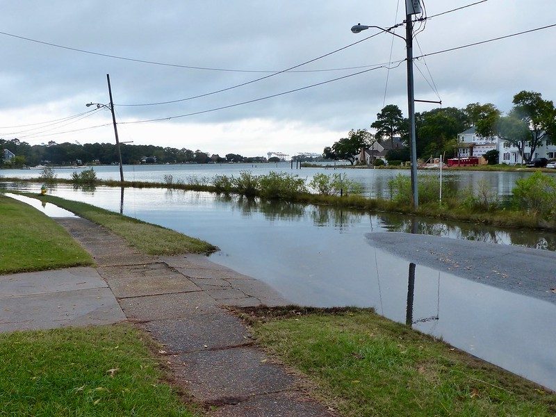
Flooding in the Hampton Roads area of the Chesapeake Bay. Photo courtesy of the Virginia Institute of Marine Science.
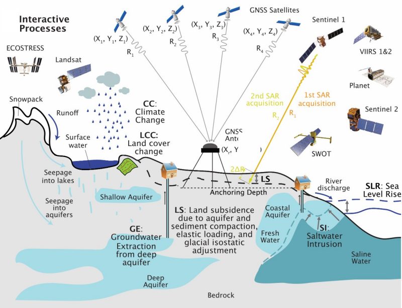
Groundwater is a vital source of freshwater for many communities worldwide, but unearthing large amounts of it causes land to sink — rock falling in on itself because there is no water to hold it up. Large parts of the coastal land in the Chesapeake Bay subside significantly every year. Although there are several driving factors for land sinking, groundwater depletion is the main cause.
When land around waterways subsides, flooding caused by rising sea levels and storms can become even more devastating. In that way, water use and environmental security are intertwined in this region. The Chesapeake Bay is also home to 11 federally and state recognized Indigenous tribes living along coasts, rivers, and floodplains where water-extracting practices threaten their land and freshwater supply.
Can we continue using groundwater without causing land to sink and flood? The NASA Research Opportunities in Space and Earth Science program awarded $1.3 million to Susanna Werth from the College of Science and collaborators from the Department of Geosciences, tribal consultants, University of Virginia, Virginia Institute of Marine Science, and Virginia Department of Environmental Quality to address this water and environmental security challenge.
“This research is vital for the region for sustainable water resources, resilient communities, and a secure environment,” said Werth, assistant professor of hydrology and remote sensing in the Department of Geosciences.
With this funding, the team will analyze remote sensing data and design physical model experiments to provide estimates of environmental change based on various water management and climate scenarios. The information gathered will inform decision-makers about which water extraction practices will likely reduce flooding and improve water quality. The goal: allow them to make more equitable choices and improve water security and flood resiliency for everyone in the region, including the most vulnerable coastal communities and tribes.
To achieve this, earth scientists will work in coordination with water managers and policy experts to tackle interwoven dependencies between the environment, its resources, decision-making, and people’s needs. Such dependencies occur and will be addressed at various temporal and spatial extents, reaching from days to decades and, respectively, from a single town, farm, or manufacturing site to the entire central North Atlantic Coastal Plain.
“Improper water resource use impacts people, and in the Chesapeake Bay, this impact is different across demographics and income boundaries, and especially low-income and tribal communities are affected the most. We want to propel data analytics to bolster human decision-making, environmental security, and justice within intricate systems involving multiple stakeholders subject to changing environments, climate, and needs,” said Werth.
Joining Werth are co-principal investigators George Allen and Manoochehr Shirzaei, also from the Department of Geosciences.
The four ultimate goals of the project are
- Continuous and high-resolution satellite-based monitoring of land subsidence and environmental change in the coastal plain
- To understand the impact of groundwater and surface water use, sea level rise, and land cover change on land deformation, flooding risks and water quality in the North Atlantic region
- Predict the extent of these impacts for the near future, based on different water management scenarios
- Analyze scenarios together with law and policy to propose water management practices that integrate the needs of coastal tribes and people across income boundaries
Werth is excited about the opportunity to be “embedded into the local communities and issues.” The project is expected to span the next three to four years.