2022 | Drought Indicators for Crop Insurance Relief
FACULTY SEED GRANT | Global Change Center
Reassessing Drought Indicators Used to Issue Automated Relief Payments in the US Crop Insurance Program
INVESTIGATORS:
- Dr. Elinor Benami, Agricultural and Applied Economics
- Dr. Manoochehr Shirzaei, Geosciences
This study is funded jointly by the Global Change Center at Virginia Tech and the Institute for Society, Culture and Environment (ISCE).
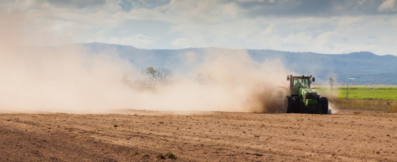
The U.S. Federal Crop Insurance Program (FCIP) began in the wake of the Dust Bowl of the late 1930s in an effort to guard the US agricultural sector against the catastrophic variability in prices and weather that impoverished communities, yielded acute food insecurity, and fundamentally reconfigured the agrarian landscape of the US for generations that followed (Hansen & Libecap, 2004; Hornbeck, 2012; Rosch [CRS], 2021). Among the several insurance options currently offered by the FCIP, in 2007 a new policy was made available to protect US pasture, forage, and rangelands against the single peril of reduced precipitation. Over the nearly fifteen years since its launch, this program – called the Pasture, Rangeland, and Forage Rainfall Index program, or PRF-RI – has grown to account for 37% of the total acreage insured in the US agricultural insurance portfolio, with the number of policies sold increasing year upon year (RMA, 2022).
As the popularity of the PRF-RI program has grown, so have questions arisen about its design and the extent to which it effectively serves as a mechanism to protect producers across the US (Keller & Saitone, 2022; Yu et al., 2019), especially in light of recent severe droughts, gaps in station coverage that serve as important inputs to the determining the correspondence of the program payouts to realized losses, as well as projected changes in the distribution of extreme weather events. In addition to the increasingly-popular rainfall index, the USDA also piloted another index insurance program for a few years in the mid 2010s in ten selected western states that relied upon measures of biomass growth derived from satellite data aggregated to 8km by 8km grids (called PRF-VI, ‘VI’ indicating the vegetation index). Throughout the four years for which we have data on this pilot, enrollment was relatively limited and consistently declined, culminating in the official cancellation of this pilot program in 2016. Notably, the lackluster enrollment in the PRF-VI was generally attributed to lack of familiarity with the program rather than an underlying flaw in the design of the index (Selasco & Hungerford, 2018).
Especially as familiarity with the principles of the index insurance program have increased but as gaps in coverage across the US for the rainfall index have become more apparent, former administrators of the USDA Risk Management Agency (RMA) as well as other researchers have suggested the time may be ripe to resurrect the vegetation index as an option for producers (Van Orden et al., 2020; Willis, 2019).
The emphasis of this proposal is to examine the extent to which novel approaches to assessing environmental and vegetation conditions could shift the distribution of payouts issued to representative participants in both varieties of the US PRF safety-net programs, including the current rainfall as well as now-defunct vegetation index programs. In effect, this research proposal aims to identify opportunities to enhance policyholder welfare in ways that are consistent with the primary PRF goals of protecting against the dominant natural disaster risk for which the US Crop Insurance Program was first established and the leading peril for which it continues to issue payouts: drought.
Reference citations for project proposal description available upon request.

Each year, the GCC, with funding from the FLSI and the ISCE at Virginia Tech, accepts proposals from GCC faculty to support interdisciplinary research that will lead to collaborative proposals submitted to extramural funding sources. We are seeking projects that link multiple faculty programs and take advantage of unique combinations of expertise at VT, have societal implications and/or a policy component, deal with emerging global change issues that have regional and global significance, and have high potential to eventually leverage external resources.